GR11
The GR11 (or La Senda Pirenaica in Spanish) is the toughest hike I’ve done so far, but also the most rewarding. As you make your way from the Atlantic Ocean towards the Mediterranean the scenery changes from green rolling hills to icy mountains to sunblasted villages and exotic trees. Should you do the GR11? Well, if you’re slightly massochistic (it’s a hard hike) and can spare 50 days, it’s definitely worth considering. Continue reading for more practical information.
Looking for a slightly easier hike? Take a look at the Berliner Höhenweg!

Why hike the GR11?
For me the GR11 is about everything you’ll ever want out of a hike. In my opinion, it is a strong contender for the ‘best 500km+ hike in Europe’ prize. Below are some of the reasons why I think this is a great hike.
- Variety. Even landscapes get boring after a while. With the GR11, high mountains are interchanged with ancient villages, ice and snow with lush green pastures, dry hillsides with flowing streams.
- The people are amazing! The locals are proud of their land (and so they should be!) and to them it is a huge compliment if you go through the effort of exploring it by foot. Many times I was given food by complete strangers, even if we spoke completely different languages.
- Wild camping allows you to plan your own hike and not depend on huts and lodges. You’ll find many many many amazing places to pitch!
- The food. The Spanish kitchen ranks among the best in the world (some say it’s better than Italian, I agree). At the Refugio the Bachimaña I got fed a three course meal with duck and unlimited red wine.
- You will swim in mountain lakes and rivers!
- The weather is generally much better in the Spanish Pyrenees than in other mountain ranges in Europe. The Basque country can be an exception though, at times it feels like Schotland.
- Escape the crowd! The GR11 is a fairly new trail, which means it’s not as crowded as some of the other major hikes in Europe. Of course, there are some very popular stretches but the majority of the hike offers a certain degree of solitude.
- The wildlife. Ever seen a Lammergeier? If you did, you’ll remember. This rare vulture has a wingspan up to 2.8 meters and is extremely rare. I saw four of them during my hike!
General information
The GR11 is about 820 kilometer long and takes the average hiker some 45 days to complete. Add to that some rest days (you’ll need those) and the time it takes to get to travel to and from the trail and the whole endeavor takes about 50 days in totall. Hikers must carry food for 3-4 days at a time and a full camping set-up.
Nature of the hike
The GR11 is brutal and not well suited for beginners! Some mountain experience is recommended, as well as excellent fitness. There is some 46.000 meter of ascent and descent involved, making it hard to cover long distances. Although I don’t have official statistics, during my hike I came across many hikers that didn’t make it to the end. Exhaustion, mental fatigue and injury are the main reason people quit. I myself was limping badly at the end of the hike.
The route itself is at times quite rugged, with many passes above 2700 meters. Those who complete the full GR11 will make their way up and down steep snowfields and long stretches of boulderfields. There’s also some exposed scrambling. Another challenge are the river crossings. Without rain, they’re easy to complete. With rain, however, they become death traps.

Another aspect of the GR11 are the many kilometers you’ll spend hiking along jeep tracks and dirt roads. At times, this can be mentally draining. I remember one soul crushing descent from Collata las Coronetas (2159m) down to the village of Parzan where I spent some 12 kilometers on a dirt road in full sun. If you want to make it through the entire hike, you’ll have to put up with these sections as well so it is best to be mentally prepared!
Huts and camping on the GR11
There are many huts where hikers can shelter from incoming storms or just relax without having to pitch their tent. In general, the huts along the GR11 are among the nicest I’ve encountered. They’re cheaper than in the Alps, the food is amazing and many offer free hot showers.
Having said that, camping is still the way to go on the GR11. Often time, huts are booked full well in advance and there’s still some stretches of the GR11 without any manned accommodation. Further more, wildcamping will allow you to plan your own hike and there are many amazing spots available.

Weather on the GR11
The weather on the GR11 varies greatly. The Basque country can either be really warm and humid or rainy and foggy. The high Pyrenees are usually quite dry in the summer months with the exception of frequent and terrific thunderstorms, most of which occur in the evening and night. A large thunderstorm can render some rivers uncrosseable for 24 hours, so beware. When nearing the Mediterranean, rain becomes quite rare and temperatures can rise well above 30 degrees Celsius.

The temperatures greatly vary. At lower altitude it can be well over 30 degrees Celcius while up in the mountains the temperature can be below 5 degrees even in the middle of the day. Nightly frost is common when camping high up so make sure your sleeping gear is up to the task.
Routefinding on the GR11
Routefinding on the GR11 used to be difficult. When I hiked the trail in 2016 however, I found that many sections featured new and improved waymarking, making navigation fairly easy. I managed to hike the GR11 with only a guidebook and was fine.
On top of the new and improved waymarking, I also found some newly constructed mountain huts. This is a clear sign that the GR11 is becoming more and more accessible; it is a trail coming of age. Will it ever be possible to hike the GR11 without a tent? Who knows!
When to go?
The best time to start is the beginning of July. In August, nights get shorter and some rivers might dry up, leaving you to search for water. In high snow years, some passes are hard to cross. Particularly the Cuello the Tebarrai (2765m) is a tough battle, especially for those inexperienced with snow conditions. An early June start is therefore not recommended.
Guidebook
Brian Johnson has written an excellent guidebook for the GR11, with a good route description. It has a detailed and reliable water report, notes good places to (wild)camp and has solid information on where to stock up on supplies. It is a must buy for those considering the GR11.
Getting to the GR11
The GR11 starts in Irún, a town on the border with France (actually it starts at Cabo de Higuer before making its way through the industrial outskirts of Hondarribia and Irún). You can reach Irún directly by train from Paris or Bilbao.
The GR11 ends at Cap de Creus. Hikers who finish there usually take a taxi or hitchhike to Cadaqúes, where they can take a direct bus to Barcelona.
Sections of the GR11
Perhaps you don’t have time to hike the entire GR11 but you still want to have some taste of the Spanish Pyrenees. Or perhaps you’re wondering which part of the hike is the most worthwile. For you I have divided the trail into four sections, each lasting between ten to fourteen days of hiking. Of course, you could cut these sections short by leaving the trail at one of the many villages the GR11 comes across.
The Basque country and Navarra
From: Irún
To: Candanchú
This section takes about ten days of hiking and sees you cross the green, rolling hills of the Basque country. Slowly the hills become more rugged untill you enter the Pyrenees. The final two days are proper mountain hikes, with steep ascents and descents. The route, however, poses no technical difficulty. Be aware that thick and persistent fog can make navigation difficult as well as making some stages hard, boring slogs. In Navarra thunderstorms can drive you of the heights by mid-afternoon.
Despite not being an all-out mountain section, this section is still quite tough. Days are long and there is significant ascent and descent. The main attractions of this section are the ancient villages with excellent food, the many green, rolling ridges offering views into both France and Spain and Aguas Tuertas, a hidden valley featuring a prehistoric burial site and a small river winding its way across the valley bottom.

This section starts in the easy to reach Irún and ends in Candanchú. From Candanchú it is a short hike down the valley to the Canfranc Estación trainstation. From Canfranc Estación there are buses into France and trains into the Spanish mainland.
The High Pyrenees
From: Candanchú
To: la Guingueta d’Àneu
This section is the absolute highlight of the GR11 and takes some 14 days of hiking to complete. As to be expected, hiking at altitude can be very challenging. I recommend that only experienced hikers take on this section as it features steep snowfields, long boulderfields, awkward and exposed scrambling and river crossings. Do not plan this hike in early summer as snowcover can make many passes and rivers impossible to cross without significant mountaineering skills and equipment.

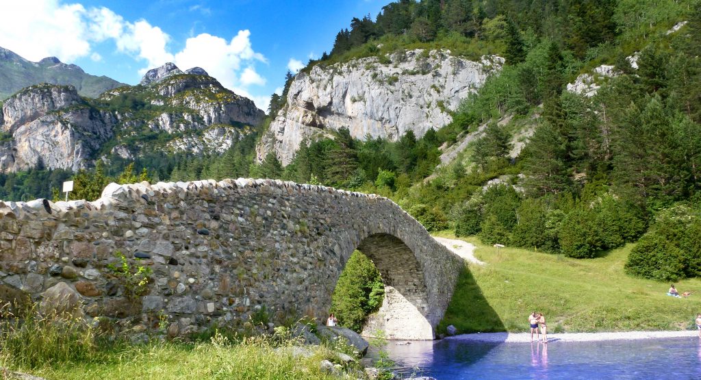
Highlights of this section include the (snowcovered) ascent to the Cuello de Tebarrai (2765m), the medieval bridge (complete with swimming hole) next to the campground at San Nicolás de Bujaruelo, the entire stretch from Refugio de Góriz above the Ordesa canyon to Refugio de Pineto and the thousand lakes of national park Aigüestortes above Espot.
You can reach this section from Canfranc Estación and hiking up the valley to connect with the GR11. Alternatively, you can take the train to Sabiñánigo and hitchhike to Sallent de Gállego. This will allow you to skip the rather uninteresting dayhike from Candanchú to Sallent de Gállego, which features a particularly long and dangerous roadhike. From la Guingueta d’Àneu you can take the bus to Barcelona and Lleida.
The Eastern Pyrenees
From: la Guingueta d’Àneu
To: Puigcerdà
In this section the nature of the terrain starts to change. The climate changes from high Alpine to Mediterranean; the treeline goes up and there’s no snow left on the high passes. Although there are no technical difficulties with this section, the hiking remains tough. It takes some ten days of hiking to complete this section, but those who are thru-hiking will likely be a bit faster.
This section starts out at a lower altitude, staying well South of the highest mountains. Hiking is often done on ancient paths between Medieval villages, a nice change of pace from the high mountains of last weeks. The section ends with the crossing of Andorra and the scenic descend to Puigcerdà.

Highlights of this section include the medieval villages between la Guingueta d’Àneu and Àreu, the very welcoming Refuge in Estaon, the incredibly scenic crossing in and out of Andorra and the descent towards Puigcerdà.
You can reach this section by taking the bus from Lleida or Barcelona to la Guingueta d’Àneu. Puigcerdà is an international trainstation with links to Toulouse and Barcelona.
The Mediterranean
From: Puigcerdà
To: Cap de Creus
The final section of the GR11 takes some ten days of hiking but thru-hikers will probably be a bit faster at this point. The section crosses the last of the Pyrenees before slowly dropping down to the sea. The final stages consist mostly of dirt roads. When altitude is lost, heat can become a problem. Temperatures well over 30 degrees Celsius are the norm in summer. Furthermore, some of the stages can be quite long.

Highlights of this section include the ridgehike after climbing up from Puigcerdà, the final stretch of high mountains right after Núria, the pictoresque village of Beget (with swimming hole beneath the Medieval bridge), the densely forrested stretch between Beget and Albanyà and finally reaching the sea at Llançà.
You can easily reach this section by taking the train from Barcelona or Toulouse to Puigcerdà. By contrast, Cap the Creus has no connections with public transport. Most hikers hitchhike (or share a taxi) to Cadaqués, which has a bus service to Barcelona.

21 Comments
Alistair
Awesome guide! Thanks so much, I’m looking to do the GR11 this summer and your guide is super personal and useful.
Kees
Glad you liked it! Happy to help 🙂
Hopefully, you’ll be able to go through with your hike this year. And otherwise, there’s always next year. The mountains will wait!
Carolyn
I have been planning my hike for the GR11 since I finished the Dolomites Alta Via 1 last year. I have reservations, air, etc but now the pandemic! Do you think it will be open for an American to hike by the beginning of July?
Kees
Hi Carolyn,
It’s heart breaking to hear of so many hikers whose plans fall foul of the pandemic. It’s honestly hard to predict how things will look like even a few weeks from now. The latest news regarding Spain is that they’ll open up for foreign tourists in July, which would allow you to start hiking. Bear in mind though that many things can change. In any rate, things will be different from how they normally are. I don’t know if mountain huts will be open. The same goes for the many cafés, bars and hotels along the trail. I’d recommend to do proper research before flying in.
Good luck!
Kees
simbo
thanks a lot bro!
I am about to go or at least do a part of it. i wanna keep going and do the camino del norte afterwards.
one question, how did you manage to fitt stuff in a 30l????
I’m carrying like the most necessary with sleeping stuff, gas cooker, warm cloths, with water and food I’m having a full 75l backpack.
thanks again, blessings!
sea
Kees
A bit late but I fit everything in a 30L pack because I went extremely minimalistic. I used a flat tarp with polycro groundsheet, had one short sleeve, one long sleeve etc. It was super light, which was nice, but it wasn’t comfortable. Anyhow, hope you had a great trip!
Chase Tucker
This is a really nice little overview thanks! I start on the 23rd August from Irun. Walking home to Barcelona with the wind at my back hopefully 🙂 Filming it for youtube as well.
Kees
Hi Chase, only just saw your comment! Great videos on YouTube, hope you had fun!
Lars Jakob Jensen
Hey Kees – thanks for the guide and tips 🙂
Is it possible to make shortcuts now and then and skipping some descent/ascent by not going down in valleys to the cities?
My thought is wether you sometimes can carry more food and then stay high instead of always following the official route into valleys to visit towns. I will carry camping gear of course.
Hope to go this summer 🙂
Kees
Hi Lars,
Sorry for the late reply, I somehow didn’t receive any notification. On the whole route, I felt it wasn’t possible to cut out descent and ascent as most valleys are oriented North-South and the GR11 runs West-East. If you really want to stay high, you should look into the Haute Route of the Pyrenees. It follows the main ridge of the Pyrenees and as such is more difficult and remote but cuts out a some of the ascent and descent.
Hope the information is still useful to you!
Bavarian Wanderlust
Hi Kees,
thank‘s for your great description of the trail.
The GR11 will be part of my West Europe Thru-Hike this year from Munich to Faro de Fisterra 3300km, starting 1st June).
As the main part of my route is quite warm during the summer month and I opt for a Apex 133 Quilt with a rating of 5 degree celsius I still considering to swap the quilt for the GR11 to a warmer quilt or adding a fleece layer instead.
What were the lowest temperatures you experienced back in 2016 during the night?
How many of these coldest nights did you experience? (If there is only 2-3 nights with 0 degree I could handle the temperature with my rain gear on)
Best regards
Kees
Hi Lars,
That sounds like an awesome trek! Personally I’d want some decently warm layers for the Pyrenees. A five degree sleeping bag would be pushing it as I encountered sub-zero temps regularly on the higher parts of the trail. Factor in the wind and it could be quite cold at times. The sleeping bag I used had a 3C comfort rating and a -2 comfort limit. It also depends on your campsite selection though. Down in the valleys temps will stay well above freezing. I slept underneath a flat tarp without any inner by the way, so a double walled shelter would also help increase temps of your sleeping set up. When compared to the Alps though, the Pyrenees are definitely much milder (most of the time), especially if you stay South of the watershed.
In any case: happy trails!
Sofie
Nice to Read this ! I’m planning on walking the gr11 in augustus and september, do you know if in september the huts and are still open? Don’t know how long the walking season is.
Sofie
Morgan Janovec
I’m looking to hike from Irun to Candanchu next summer. Ideally, I would like to be able to camp most nights. Would this be possible on this section?
Kees
Hi Morgan,
Yes, wildcamping on this section is no problem, I’ve done it plenty of time myself. The best camping spots are found away from the villages though, so you may want to plan out accordingly. I’d recommend getting the GR11 guidebook by Brian Johnson, published by Cicerone Press. He has excellent notes on wildcamping and where one can find water or buy supplies.
Kevin
I Kees, great account of the GR11, you really make it sound fascinating. I would like to do this trek but am getting older and my fitness level is not great. I would therefore like to spend more time on the route and, if needed, avoid some of the higher passes. I would like to to this trek in April, May, June and / or July. Is there any reasons, such as weather, that this is not advisable?
Kees
Hi Kevin,
Great to hear my blog has inspired you! Don’t worry too much about your age, I’ve had people over 60 easily kick my butt when it came to long distance trekking and I’ve seen people over 80 on top of high mountain passes. I’m not gonna lie about the fitness level required as this is very important. I’d recommend doing lots of hiking beforehand; aim for 20-25km day hikes in the weekend. This also lets you test gear and break in your shoes. If you’re overweight, try and lose the fat. In any case, I’d recommend a gym membership and doing weighted squats and deadlifts as well as planking to increase core strenght. I’ve always found my upcoming hikes a great motivation to get or stay in shape! In any case, don’t do running as that’s very injury prone. Overall you don’t have to be super human but being reasonably fit and able bodied is highly recommended.
As for when to hike: you shouldn’t start earlier than late june. Before that there’s too much snow on the trail. You could take untill half september to complete the entire thing. Even if you wouldn’t make it in that time frame, you could consider it two and half months well spent. There’s also quite a lot of manned huts along the trail so you wouldn’t need to camp every night, making it less hardcore.
As for gear, your pack doesn’t need to be super big as there’s a lot of high quality ultralight gear avalaible these days. I was able to fit all of my gear and four days worth of food into a 34 liter backpack. Just make sure you’re not hauling a 3 kilo tent around as that’s totally unnecesary.
Last but not least: buy the guidebook for the trail from Cicerone Press. It’s very detailed and gives great info on accommodation, resupply, difficulty levels of each stretch as well as an excellent water report.
Hope this info helped you!
Cheers,
Kees
Leontien
Hi Kees,
Thank you so much for your inspiring account of your GR11 adventure, I enjoyed reading and viewing it!
We’ll walk the trail this summer (from somewhere around June 25th), and are planning to start in Cap de Creus instead of the Basque country, as we love the latter so much we prefer to arrive there (and maybe spend an additional week in the area).
The plan to do so originates from the moment we bought the wonderful (picture)book ‘Los Pirineos de cabo a cabo’ by Marta Viladot Santaló some 10 years ago, and her and the photographer travelled east to west.
Is there any reason you know of – other than the fact that the GR11 Cicerone guide by Brian Johnson describes it west to east – NOT to start in Cap de Creus?
Hope to hear from you!
Hans and Leontien
Lulú "TARS"
Hi Kees,
Did you use any app to navigate the trail?
Which would be another amazing source to prepare for the trail besides the guidebook that you mention?
Cheers,
Lulú “TARS”
Rebekka Schwesig
Hi Kees and everyone,
I am planning to walk a 18 days long part of the GR11 this September.
Currently, I am wondering wether finding drinkable water will be a huge problem for us.
I have read that many rivers and lakes have low water levels.
Do you know how water sources on the GR11 are this year? If not, do you have an idea who I could ask for information on current conditions on the track?
Thank you and greetings from Dresden, Germany.
Bekki
Bekki
Dear Kees and everyone,
I am planning to walk parts of the GR11 in September this year.
Currently, I am wondering wether finding enough drinkable water will be a problem on track. As this summer happens to be very dry and river and lake levels are very low, I am scared to not find enough water sources.
Do you know how water conditions are this year? If not, do you have an idea to whom I could write to get information on current conditions?
Thank you in advance, Bekki